Laguna 69 is located a few hours from the trekking capital of Peru, Huaraz. The lake is situated 4600m above sea level and there are so many lakes in the area that haven’t properly named them all, hence the number. This hike is one of the most well known in the region and due to its altitude I decided to leave myself a few days to acclimatise in Huaraz beforehand. Initially I was a little worried about the altitude of the trek and I’d read countless blogs about the hike all with one thing in common – it was going to be tough. After a few days I decided that I was as ready as I’d ever be and booked my tour which cost 30 soles (£6.80) and stocked up on snacks and water for the next day.
I jumped out of bed at 4am with a mixture of nerves and excitement as the transport was to pick me up at 4.30am. Due to it’s location in the mountains Huaraz can be pretty chilly, especially at night so I put on my many layers of clothing, packed my waterproofs (it was also the start of rainy season) and some snacks – sadly no time for that morning cuppa – I then waited for my transport to pick me up from my hostel. There were a few others waiting for this trek and various other tours and just before 5am we were on our way.
We drove for roughly two hours from Huaraz and stopped first at a local restaurant in the middle of the mountains where you can buy breakfast and tea. It was still early, around 7am and there was a lot of fog and cloud cover so we couldn’t see the mountains. I opted for some coca leaf tea (Peruvians swear by this leaf to help with altitude sickness) as a warm cuppa on the cold morning was very welcomed. After around 30 minutes we got back on the bus and were on our way again.
Upon entering the national park we stopped at a control point and paid a further s/30 for entrance. There are several lagunas of varying sizes on the way up to where the trek starts. They are all beautiful, framed by the surrounding mountains and are a brilliant blue colour. There is one in particular that the bus stops at for five minutes so you can take a look. You can see all the way down the valleys and also a large snowy mountain to one side. Normally they stop on the way up but due to the cloud cover we drove straight past it only to stop and visit on the way back down instead. It was a bit overcast so my cheap Samsung phone camera definitely doesn’t do it justice.
On the way there our guide started telling us a bit of what to expect on the trek. There would be three ‘flat’ sections each followed by a ‘zig zag’. The trek takes 2-3 hours there depending on your ability and around two hours to descend.
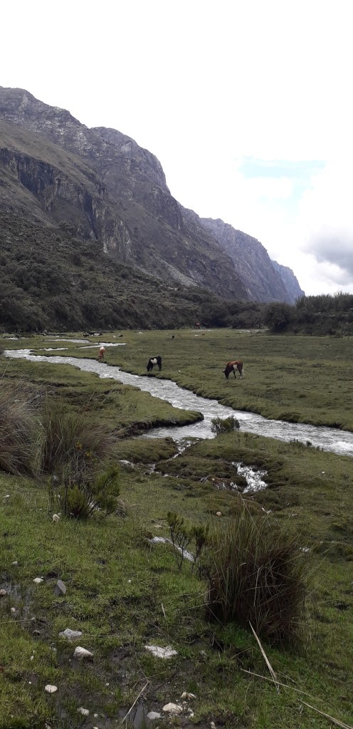
On the very first section of the trek it seemed as though we had arrived in some sort of magical forest that looked as if it could have been the set for the Hobbit. The trees had a reddish brown bark and a perfectly meandered river wound through the marshland with beautiful cattle grazing either side. This section was relatively flat so I powered through in order to give myself more time for the trickier sections. Even at the start, walking at a pretty rapid pace I found myself more breathless than I would usually be because of the altitude.
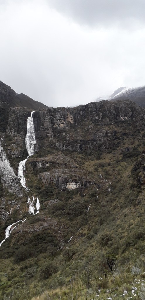
At the end of this first marshy area was the first zig-zag. The path narrowed and there were some small streams running across it in sections. We started to ascend and were rewarded with views of the valley, although it was still a little clouded. There was a large cascade to our left but the top remained hidden in the clouds. This section really dragged on but wasn’t too steep. Towards the top of this mountain my legs started to ache and I had to pause a bit to regain my breath. People spread out and you’d pass someone taking a break only to have them pass you shortly after when you were taking one.
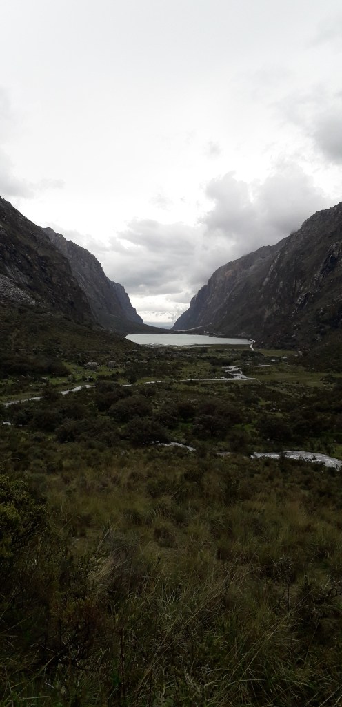
After around 45 minutes the path flattened out but then we got a glimpse of the second zig-zag and just how steep it was. Other groups had already started this section and I could see people pausing along the track to get their breath back. This zig-zag was relatively short but quite difficult, everyone started to feel the effects of the altitude by this point and I couldn’t believe how many times I had to stop! The guide had told us before that we’d know when we’d reached the halfway point as there was a small lake there. At the top of this zig-zag we found the lake (more like a pond) and I was relieved that I was making good time.
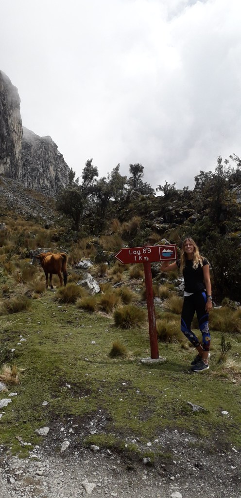
From the small lake there was another section of marshland where more cows are wandering. Large cobblestones were placed across some rivers and boggy areas for you to cross so that you don’t get your feet wet. This section was quite short and I was pleased to see the 1km left sign, at this point we were also greeted by the sight of a large mountain staring at us and the path disappeared towards the top, I was thinking surely we’re not walking all the way up there?!
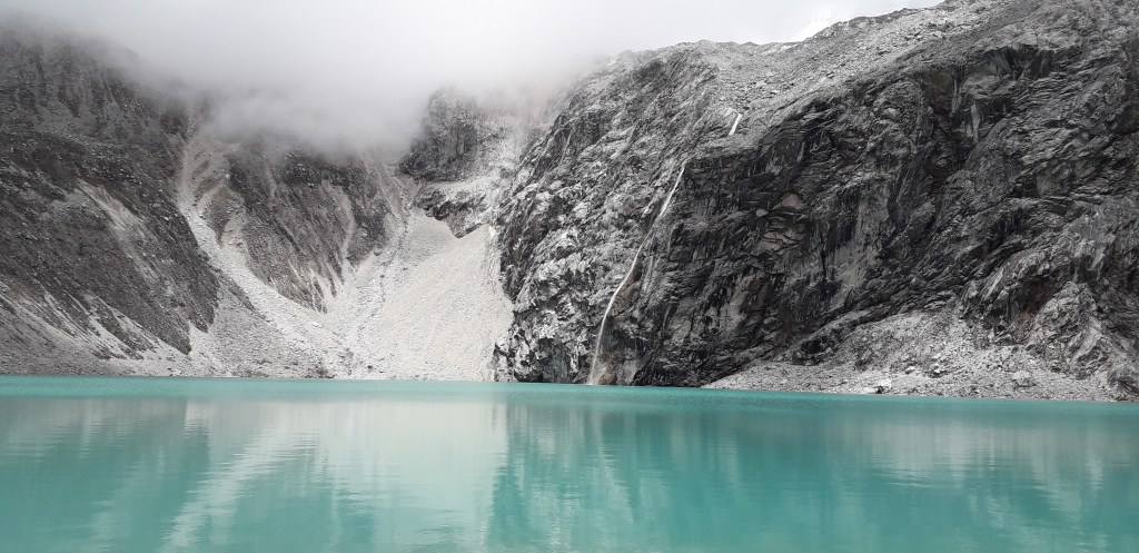
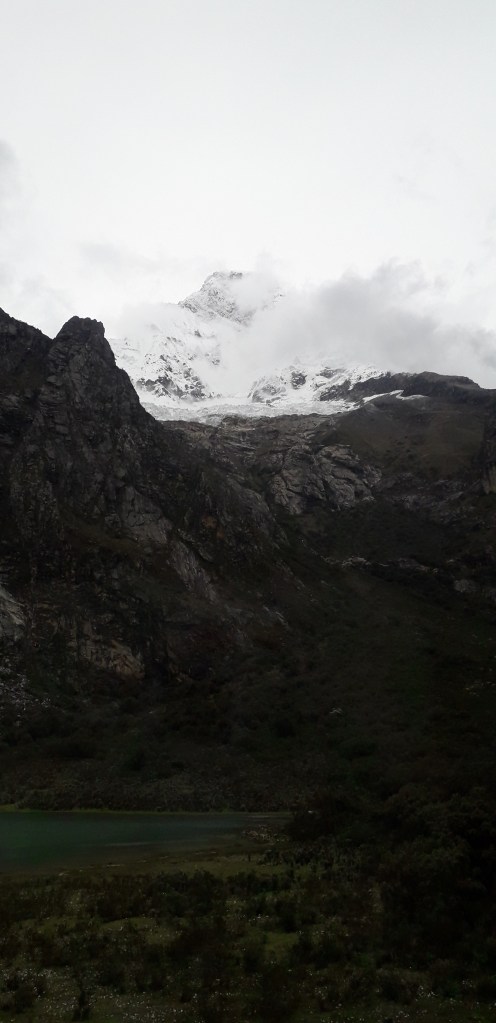
I chose this point to have a short break, eat some of my snacks and then I started my way up the final stretch. It starts off fairly gently and I thought that it was going to be easier than I anticipated. I could see people walking closer to the top and I told myself it’s only that far, I can do that! The path just kept on getting steeper and steeper and the altitude harder and harder. I’d been leapfrogging people the whole time and some people were really starting to feel exhausted. Every corner I turned there was more and more path that I hadn’t seen before, I had no idea when it would end. I was really really breathless at this point, every 30 steps or so I’d have to pause for 30 seconds so that my breath could recover. Some of us were speculating how close we were to the top. Finally, after what must have been a good 45 minutes I reached the top. You come over the top, walk on a flat path alongside a river that flows out of the lake and then you get the first glimpse of the bright turquoise waters and you’re there standing above the lake. It was so relieving to know I’d actually reached it. The view of the lake is spectacular, it’s such a tranquil place and incredibly picturesque. It took me a good 5 or 10 to begin to really appreciate it, I was tired, a little dizzy and disorientated from the trek, my hands and forearms had pins and needles from the lack of oxygen – but I was impressed I’d actually done it. People were relaxing on the boulders around the shore of the lake and people were speaking to me as I arrived, I had to think awhile to reply because my mind was just too tired to work properly! I sat down, had some water and once I’d fully recovered I was able to absorb the beauty of the place. The colour of the rock on the surrounding mountains is a great contrast that reflects in the lakes waters and I could see huge glaciers and snow topped mountains peeking through the clouds.
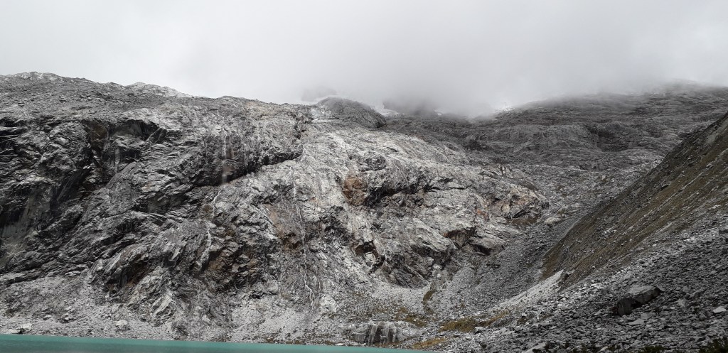
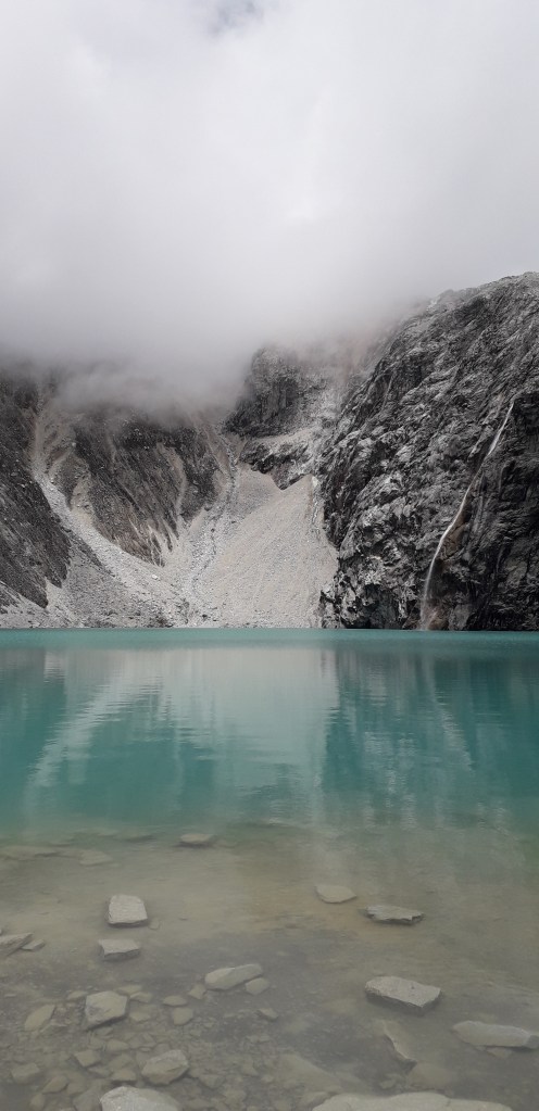
I know the lake is probably even more impressive in high season when there is less cloud but the clouds meant that the view was constantly shifting. Every so often a different mountain peak or glacier would come into view and a sunny patch would like up the lakes waters so they were even more intense in their colour. Whilst sitting there chatting and taking in the view we could hear the distant rumble glaciers cracking which was a bit eerie.
After an hour or so taking in the view at the top it was time to head back down. As we were still at altitude I was expecting to find the walk back a little difficult, but it seemed an absolute breeze compared to the way up! The path also seemed a lot steeper than I remembered which would have been partly why we were struggling so much on the way up.
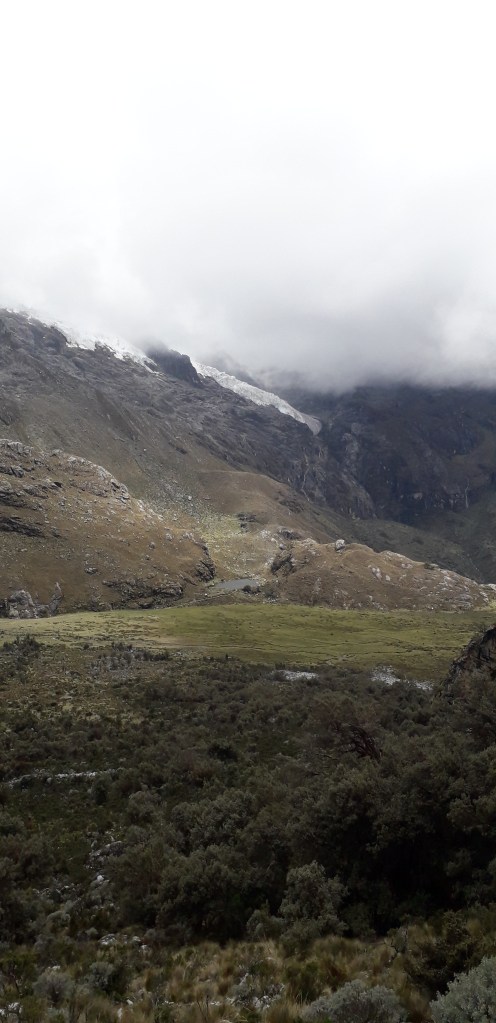
On our way back most of the clouds had dissipated to revel amazing views of the valley and overall, I think I loved these views more than the actual lake itself. Every corner of the path we turned we would stop and observe the view and want to take a photo. The whole way down we were exclaiming to each other just how spectacular it was. When you’re that high the views go through the valleys forever, every mountain you descend opens up a whole new perspective. All of the glaciers and snowy peaks that were hidden in the morning were now exposed and they were countless.
I made a point of turning around every so often to look back at where we had walked from. I couldn’t believe how far we’d actually walked up, it was mountains away! I had no trouble with walking down and towards the end any effects of altitude I’d had were fast fading. I reached the waiting point for the rest of our group to return and felt a strange mix of fatigue and pride that I’d actually just completed the hike, I didn’t suffer tremendously from altitude sickness and it hadn’t even rained! Once our whole group had returned we walked back to the bus, seeing yet another landscape with a huge lake that we’d forgotten we parked next to.
In the morning I slept on the bus pretty much the whole way up but whilst returning I could see just how many valleys we’d driven through, the landscape of the Andes is breathtakingly beautiful. The road was pretty intimidating due to the shear drops that seemed inches away from the vehicles tread. I absorbed the views of the mountains, communities and farms where local farmers were going about their daily lives, collecting crops by hand into small sacks – no tractors anywhere to be seen. A few hours later when we arrived back to Huaraz I was in a bit of a daze, a hot shower, food and rest was definitely in need. I filled in a couple of my roommates about my adventure and cozied up in bed with a cup of tea, followed by the best night’s sleep I’d had since I arrived in Huaraz.
Laguna 69 was definitely one of the most challenging things that I’ve done, not just physically because of the altitude but mentally too, but it was absolutely worth it and I won’t forget the stunning landscapes in a hurry.
